Anyone around the water this past week has witnessed a very low water level. I’m calling it the “Great Blow Out Of Feb 2025”. There were many sand bars exposed, dry docks and some lagoons could be walked across. I posted a couple photos and shared details about it to inform. It got wings and the topic has trended, but many posts I see are loaded with jokesters and misinformation.
A tsunami is not coming. The NJ Forest Service did NOT pump the bay dry to water the Pinelands which are in a sever drought. It’s an epic time for clamming! Also a great time to inspect a bulkhead and clean up a dock slip. But I’m sure that cell phone you dropped in last summer is trash.
Why does Barnegat Bay has no – low water?
Here’s some information on the extremely low Barnegat Bay water level phenomenon that is rare this extreme but not uncommon.

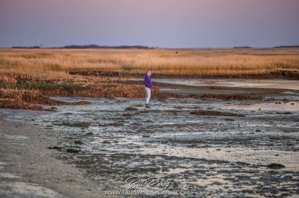
Bill Purdy @fairwindsphoto captured this photo on the LBI bayside. It would normally be waist deep where his daughter stands. A “blow out tide” is a phenomenon as a result of extreme west- north/west winds.
Barnegat Bay Blow Out Tide
Plain and simple… It’s called a blow out tide! This low water event is primarily due to the wind…
- The wind’s direction – West, North / West Winds
- The wind’s speed – Powerful Gale / Tropical force winds
- The wind’s duration – 36-48+ Hour Duration
- The wind’s area/distance – Large Surface Area
It’s the recipe for a very large, broad and powerful fetch which pushed the water out. Just the opposite happens during coastal large storms when coastal storms create a very large fetch that pushes water in creating flooding events (and also generate large waves/surf).
Another factor is the barometer and barometric pressure gradients. Without getting too far into the weeds. Wind is created by pressure differences with air moving from areas of high pressure to areas to low pressure. But ALSO high pressure can cause lower water levels (and low pressure can raise the water level) compared to the predicted tides for a specific date.
Nearly Hurricane Force Winds
The evening of Sunday February 16th and most of the day Monday (2/17) were very windy. A powerful low pressure system with gale force (39-54mph) – tropical storm force west winds (39 to 73mph) moved through the area Sunday. Behind it was strong high pressure. The large gradient between the two created a board area of strong offshore winds. For clarification, west winds aka offshore winds, come from the west and blow in the direct of offshore.
Sunday and Monday the area had sustained 30MPH+ winds with gusts to 50MPH++!
- Atlantic City Airport: 71MPH!!! 74MPH is Cat1 Hurricane!
- Beach Haven peaked at 56MPH
- Island Beach State Park 65MPH
These winds pushed the water out of the bay and each ebb tide only helped drain the bay. These same winds blocked the subsequent flood tides, preventing the incoming water.
What is tide?
Most all anglers (should) know about tides but or those who don’t… The tide is the vertical elevation of water, the rise and fall of seawater that is caused by the moon’s, and a less part the sun’s (further away) gravitational pull. The normal everyday water elevation tidal change is about 1.5′ for most locations in our local area.
Local Observations
Taking look at the USGS Tide Elevation Gauges in the area you’ll see the super low tide elevations recorded at both the Waretown and Barnegat Light locations. The water level was about 2.5-3.5′ below normal.
Waretown Tidal Elevation: The west side of the bay location recorded a low of -2.42′ on 2/18/25 at 8:30PM. Statistics based on two years of data from USGS share the mean to be -0.17′.
Barnegat Light Tidal Elevation: The east side of the bay, near the Inlet location recorded a low of -3.73′ on 2/18/25 at 5:24PM. The location’s 22 year mean is -0.23′. Looking at this chart you will see more tide range due to the location.

Some say the event, “is because of neap tide” or “it’s because of spring tides.” That is not the case. This blow out event occurred at mid moon phase ~50% so the moon had little to no effect. The moon’s effect on tides is greatest, most extreme at the new 0% and full 100% phases and weak at the 50% stage.
- Neap Tides have the smallest tidal range, less extreme, resulting in lower high tides and higher low tides.
- Spring Tides have the largest tidal range, most extreme, resulting in higher highs and lower lows. Spring tides have nothing to do with the season we call Spring! It happens during new moon and full moon phases of the lunar cycle.
- The King Tide is the year’s highest tide. It’s the largest spring tide of the year. It occur when a new or full moon coincides with the moon’s perigee (closest to Earth in its orbit).

Additional Factors
An additional factor that did not cause but certainly didn’t help is the current drought. There’s little to low/no, flow out of the many creeks and rivers which drain into the Barnegat Bay. The entire Barnegat Bay watershed and broader area/state is in a sever/extreme drought. New Jersey and especially South Jersey is experiencing one of the driest periods of the 10-15 years. There has been little rain since this past August. If you read my end of year 2024 LBI Fishing Recap then you should know that this issue isn’t new, “October was BONE DRY, the driest since 1895!

Remembering Back
What a crazy blowout! One of the lowest and longest duration blow out tide in a long time! This event beat the last extreme blowout we can remember in early Jan 2108. Then we had a blowout in the frigid cold. The west wind blew out the tide and then it seemed like the hard freeze kept rom coming back in. Once it did a lot of pilings were lifted and docks damaged. Here’s a photo (below) from Jan 7th 2018.
Do you recall a super low extreme blow out tide? Share you memory.

This is such a great explanation of the blow out tide. Not to mention the low flow of water from the creeks.
I’ve tried to explain to some but not this well. Thanks!