The Double Creek Channel Shoaling situation is a hazard to navigation. This was originally published on 4/19/2021 but since the hazard still exists we’ve updated this on 8/12/22.
Barnegat Bay’s Double Creek Channel is well know for shoaling and shifting sand bars and in recent years it was closed. Right now (04/2021 and still in 08/2022) there’s two areas of potential navigation hazard in Double Creek. Shallow draft boats have no issue however at mid and lower tides some vessels are grounding.
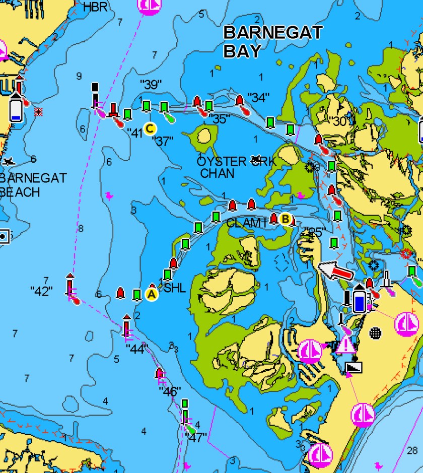
Notice To Mariners – Double Creek Channel Shoaling – Shallow Water Hazard.
The best way for medium and large size vessels is always Oyster Creek Channel.

South End Of Double Creek – Hazard “A”
The southern end of Double Creek Channel at the elbow is pinching off again. For many years this area has shoaled. It was dredged a number of times, but never enough. At the time of this post there are two danger buoys at the site alerting mariners of the shallow water here. The area is very narrow with little to no room for error.
North East End Of Double Creek – Hazard “B”
On the northern eastern portion of Double Creek Channel, west of the tip of the Dike, there is a very shallow area inside the marked channel. It is marked by a danger buoy which is right by at Red #8 Nun Buoy. The danger buoy and #8 are both in ~5-6′ of water (depending on tide) however just to the west it is very shallow. The Green #7 Can Buoy is in very shallow water especially at low tide, +/- 1-3′ of water and even less.
This shallow area should be known by all operators/captains. Proceed with caution!
West End of Oyster Creek – Hazard “C”
Many small boats navigating westerly through Oyster Creek with a southern destinations short cut off to port in the areas of buoy 37-39. No more unless you really know what you are doing!
There is a new sandbar (sort of mini-island) that is dry even at higher tides. This is west of the classic Oyster Creeks West Dredge Spoil Island (not to be confused with OC Island East) and was the spoil site for the most recent Oyster Creek dredge work over the winter. I was told by a dredge company working this new island was named Trump Island because someone staked it out with a few Trump Flags which stood for a couple weeks.
It is not in the channel however it can catch someone off guard.
This original blog post was to highlight the shoaling in Double Creek however it is worth mentioning an area which has caught many boats high and dry. There is a sand bar creeping south and into the channel in the area of Buoy 38. Do not run this area offset to the red / north side because it might not end well. There’s much more water on the green / south side of the channel. Running straight from 37 to 39 is clear and safe water.

Navigate With Caution
Mariners must always navigate with caution. Be aware of shifting sediments which impact the entire bay. Each spring it’s best to review your common routes and adjust waypoints accordingly. This way when navigating in conditions with limited visibility you are aware of the dangers. It’s always good to have a handle on the lay of the land.
I hope this alert helps save someone from grounding and possibly injury to boat or passenger. Recently a friend witnessed a mid-range center console hit bottom (Hazard A) running on full like a brick wall. Hazard B has caught a lot of boaters too. It’s no joke!
Right now there’s no telling if and when the situation will be address.